
For developments within or in the vicinity of aerodromes, their risks to aviation safety must be identified and addressed in the design and construction phases of these projects. However, the developers engaged to perform these tasks may not have a sufficient understanding of the relevant aviation safety requirements. As consultants, we play a vital role bridging the knowledge gap between them and the various aviation stakeholders.
Limitations of Standards and Recommended Practices (SARPs)
One of the aims of International Civil Aviation Organization (ICAO) is to develop SARPs for member states to assist in managing aviation safety risks.[1] For example, ICAO Annex 14: Volume I provides the minimum design and operational recommendations that can be referenced to identify aviation risk due to developments in or near the aerodrome. SARPs are intended to cater for a multitude of operations, and the varying complexity of the aviation environment results in numerous cross-references throughout the document. The lack of graphical illustrations further limits the ability of non-aviation stakeholders in understanding the requirements. As consultants, we assist developers by filtering out the applicable clauses and provide bespoke visualisation for them to understand the risks.
3-D Visualisation Tools
In my line of work, I have been exploring different software and methods to improve project deliverables and perform better risk assessment. In this article, I will share how some of these tools can be used to visualize the aviation requirements for a better appreciation of the risks.
Obstacle Limitation Surfaces (OLS)
OLS exists to safeguard aircraft from obstacles in the vicinity of airports. The OLS illustration in ICAO Annex 14, Figure 1 (left), is generic, and the actual OLS differs between airports. Without prior aviation knowledge, developers may not be able to understand how the different OLS may affect their development and vice versa. This is where we step in to ensure that there are no lapses in safety precautions by assisting with the translation of the ICAO requirements into 3-D surfaces for developers to interact with. For example, I used Python in a previous project to generate the OLS for Singapore Changi Airport on Google Earth, Figure 1 (right). By using Google Earth, a free open-source platform, developers are now able to interact with the various surfaces via a user-friendly interface. Since the OLS is overlayed onto a base map, developers can easily identify the location of the development with respect to the OLS to assess the impact on aviation and vice versa.
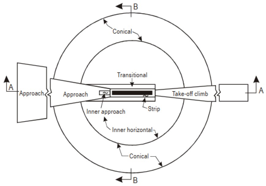
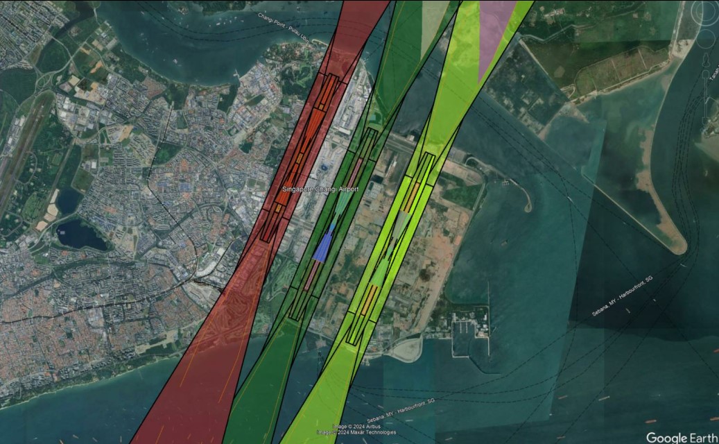
Figure 1: ICAO OLS illustration [2] (left) vs Python generated OLS on Google Earth (right)
Line-of-Sight (LOS) Impact Study
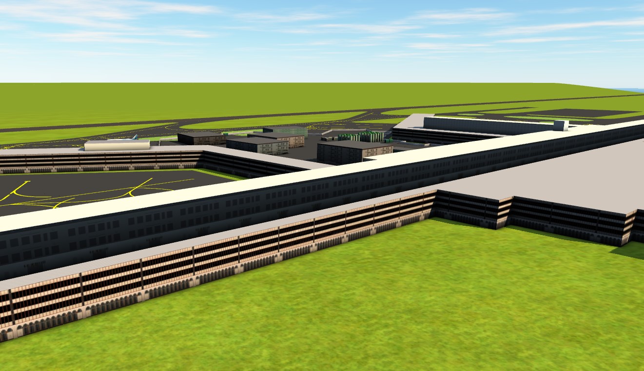
LOS is the most important factor for ATCs to ensure safe and expeditious traffic management within the airport. It is crucial that these developments do not interfere with the ATCs’ LOS within their Area of Responsibility (AoR). Drawing inspiration from architects, we can use Building Information Management (BIM) software to create a digital twin of the development within the airport, Figure 2. This allows us to accurately assess the LOS impact and create amazing visuals to justify our findings to stakeholders, increasing the chances of acceptance.
To wrap up
In conclusion, 3-D visualization software is a good tool to help aviation and non-aviation stakeholders have a better appreciation of the risks due to developments within or in the vicinity of the airport. They allow us to combine both ICAO requirements and development plans on a common platform to perform better aviation risk assessments through a digital twin concept. As the aviation industry becomes more digitalized, it will be interesting to see more such use cases to better educate the industry about aviation risks and requirements.
[1] https://skybrary.aero/articles/standards-and-recommended-practices-sarps
[2] ICAO Annex 14 Volume 1: Aerodromes
Ream more Articles and News