Drone operations – will the wind be its downfall?
In many cases, commercial drone operations are proving themselves in the field, even though discussions can easily get sidetracked by visions of mass package delivery and pizza drops. To70 is involved in projects that have the potential to transform a number of business cases, now and in the near future.
Missions that can’t wait
Two mission types that clearly show the case for drones are: (1) emergency response missions, and (2) humanitarian help deliveries. In 2024, the Dutch fire service (Brandweer) carried out 375 emergency response drone missions. For the last few years, Wings for Aid has been developing and trialing its large humanitarian cargo delivery drone.
These missions cannot wait for all of the national and international requirements to be put into place; emergency search and rescue and humanitarian help are urgent matters. Such operators need to assess the safety of their flights, and they need to do it quickly.
Why wind is a challenge
Although there are many aspects involving the assessment of flight safety, here we focus on one rapidly changing factor – particularly here in the Netherlands: wind. In classical air traffic, large aircraft spend most of their time high in the atmosphere, where conditions are often stable. Drones, almost all are very small, flying near cities spend most of their flight close to the ground in the turbulent atmospheric boundary layer.
The air interacts with the terrain and surrounding buildings. This means that areas with unsteady air and turbulence are created throughout the city. Mesoscale wind measurements are not sufficient to capture this, especially in dense urban environments A wind measurement made at the take-off location will likely not match the wind conditions at the landing zone, or maybe anywhere along the route.
So how can operators quickly make a go/no-go decision? Being overly conservative means cancelling a flight that could have been completed safely. Being overly risky means not anticipating how conditions might change during the mission.
What this means for U-space
Under the EU’s U-space regulation (2021/664), one of the six defined services is the Weather Information Service. It’s optional, but Member States can require it based on an airspace risk assessment. When required, this service must provide local meteorological data with enough spatial and temporal detail to support both flight planning and real-time execution.
That’s where it gets difficult. Near the ground, wind conditions are highly dynamic and can vary sharply across the flight path. Placing measurement stations along every possible route is simply not feasible. This is why realistic city-wide simulations capable of capturing how wind behaves across an urban environment should play a key role in delivering this service effectively.
Mapping the wind across Rotterdam
As part of research at TU Delft1 , the author used Computational Fluid Dynamics (CFD) simulations covering all of Rotterdam to quantify when and where drones could safely operate. Both wind speed and turbulence were considered as factors with a direct effect on operational risk.
One of the main results was that a drone would have needed to withstand a 12 m/s mean wind speed and a 5% turbulence level2 to be operational 90% of 2022 in Rotterdam (Figure 1). By reducing the limit to 8 m/s, drones could only have been operational about 70% of the time.
- Constrained Urban Airspace Design: Exploring future rules, strategies, and risk. ↩︎
- Turbulent level is calculated as the ratio of turbulent kinetic energy over the energy carried by the mean flow. ↩︎
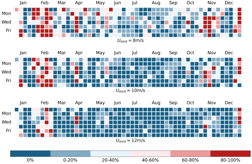
Different drone sizes will, of course, require different limits. The above data represents, drones with a maximum take-off weight of around 15 kg.
Conditions can change in minutes
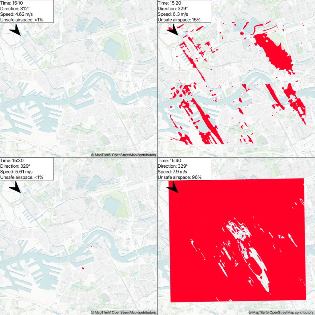
The trickier part is realising that conditions often change very quickly. What was safe a few minutes ago, can be completely unsafe a few minutes later (Figure 2). The research discussed here identified a day where the transition from safe to unsafe took only a couple of minutes. Forecasting how conditions may change before the end of a flight is critical to safe drone flight operations.
From research to operations
The research created a city-wide risk and feasibility analysis, but several gaps remain. For example, wind condition analyses will help determine where vertiports can be placed. Solving the wind challenge will require measurement campaigns and more in-depth simulations to improve our situational awareness and provide the detailed wind data that U-space services need. Real operational data and insight from ongoing essential missions is needed to move from research to reliable and safe operations.
To70’s knowledge and expertise
The integration of unmanned aviation into existing airspace is still in its early stages. As the sector matures, operators, authorities, and other stakeholders are likely to encounter similar challenges. To70 can support these parties by conducting fast-time simulations, urban CFD calculations, and digital twin development to enable data-driven decision-making for future drone operations. We can help identify optimal vertiport locations and perform third-party risk studies to ensure drone operations meet safety standards. Besides the operational knowledge, our team of experts also has extensive experience in translating unmanned aviation knowledge into clear advice for public decision-making. We contribute to the development of national and international legislation and regulations for unmanned aviation and related domains, and support the alignment and implementation of interests in often complex political and administrative environments.
Sources
- Steeds vaker inzet van drones en robots tijdens incidenten – Nederlands Instituut Publieke Veiligheid
- Operation in a humanitarian scenario
- Medische drone van start tussen Isala Zwolle en Meppel | ANWB[AY1]
- Implementing regulation – 2021/664 – EN – EUR-Lex
- Constrained Urban Airspace Design: Exploring future rules, strategies, and risk – TU Delft Research Portal
About the author
Andrés Morfín Veytia is an Aviation Consultant at to70, specialising in safe drone integration into the airspace. He recently completed his PhD at TU Delft, where his research focused on urban air traffic management, conflict prevention, and city-scale wind simulations for drone operations. He has worked on SESAR U-space projects such as Metropolis II and EUREKA. He holds a double master’s in aerospace engineering from KTH and the University of Bologna and was a research intern at NASA Langley Research Center.